A capital city spread in 55,000 Acres which would cover a total of 217 Sq.kms.
Capital Region spread across 7,420 Sq.kms.
New International Airport in Mangalagiri in 5000 Acres.
Road Corridors from Capital Amaravathi to Chennai, Bangalore, Visakhapatnam and Hyderabad.
Delhi Rajpath like Main Road for the capital city.
Chicago City like Water Taxi in River Krishna and the Canals.
Theme Parks in the 2 big Islands on River Krishna.
High Speed Railway line to Bangalore City from Amaravathi.
FINAL CAPITAL REGION PLAN:
Two new reservoirs on Kondaveeti Vaagu.
Civic and Central Parks for public.
45 kms of Water Circuit.
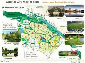
GREEN AND BLUE NETWORK:
Greenery covers 21 % of the Capital Region.
Waterways cover 3% of the region.
Waterfronts and Developed canals through out the capital along the waterways.
Recreation and amusement parks along the River.
International Cricket Stadium along River Krishna.
Golf Course and a University in the Capital City.
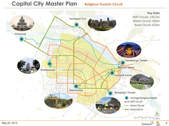
RELIGIOUS TOURISM CIRCUIT:
Integrating the Heritage and Religious nodes with the Metro, Road and Waterways.
PLANNING CONCEPT:
Brahma Stanam as per Vasthu to add positive energy from the North East direction (Eeshanyam) to the Capital Region with a View of Kanakadurga Temple, Vijayawada on one of the Axes of the Triangle Area in the Capital City.
( Singapore also believes in Vastu for construction like India does. Singapore City was also built as per Vastu)
WATER TAXI AND RIVER FRONTS:
ROAD NETWORK:
8 line express highways.
The narrowest road in the capital city would be an 80 feet road.
50 Roads would diverge from the Core Capital to various cities and towns integrating with the National Highways and newly constructed roads.
PUBLIC TRANSPORT AND METRO RAIL:
135 Kms of Metro Rail Network.
Railway track to Odarevu and Bundar Ports.
Exclusive 35 km long Cycle Track to promote eco friendly transportation and tourism. The Cycle tracks connect the Capital and the places of attractions with residential areas and metro stations.